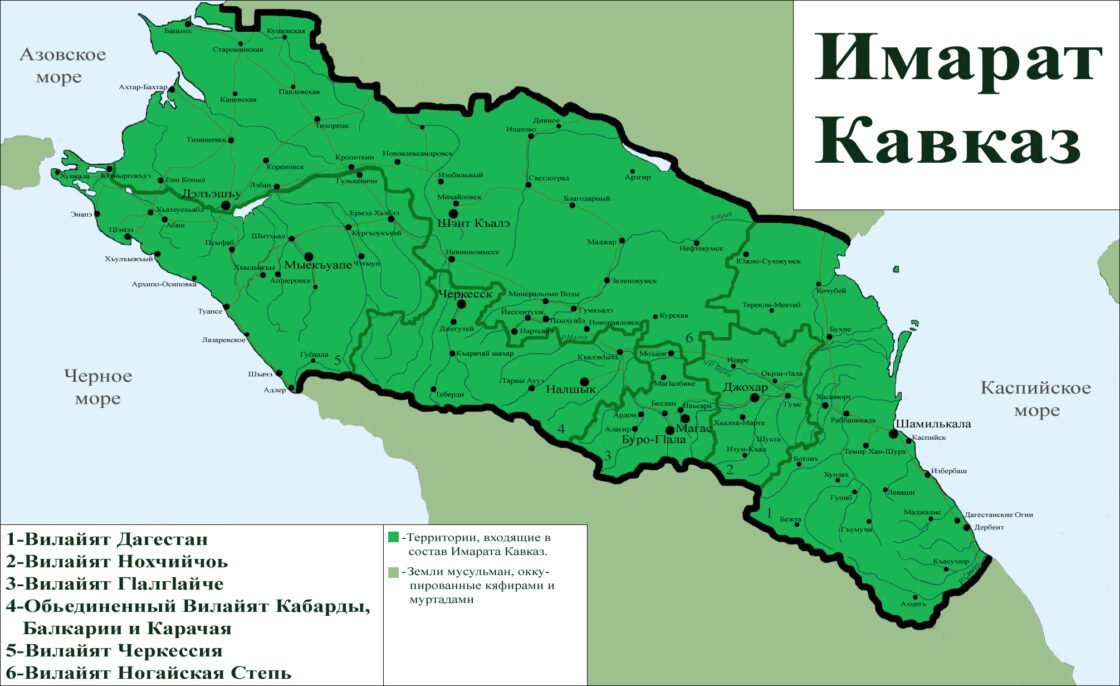
On 25 Ramadan 1428 Hijri (September 25, 2007), in the territory of the Caucasus, our Amir Dokka Abu Usman proclaimed the Caucasus Emirate. A long-awaited event took place, which all the Muslims of the Caucasus were waiting for. The Caucasus Emirate is a multinational Islamic state stretching from sea to sea, located in the northern part of the Greater Caucasus Range. It combines six vilayats, each of which has its own administrative center.
Of course, for infidels and weak-minded Muslims, Emarat remains a virtual entity, over which some laugh, and some simply do not believe in the real prospect of its existence. But for the sincere Muslims of the Caucasus, Emarat is their homeland, which unites the fraternal peoples of the Muslims of the Caucasus, and they are confident that Allah (s.w.t.) will never leave His sincere servants without support and without victory, because, as we already We know that difficulties always come with relief, by the will of Allah.
Just as confidently as we consider the Emirate to be our country, just as confidently we must know everything about it. To know what it includes, to have a better understanding of your state, in order to get rid of the gap between our real life and the virtuality in which some imagine our country, in order to pour it into our everyday life from virtuals.
And so, as we have already said, the Emirate includes six wilayats, namely: Vilayat Dagestan, Vilayat Nokhchichoy (Chechnya), Vilayat GIalgIayche (Ingushetia), United Vilayat of Kabarda, Balkaria and Karachay (abbreviated as KBK), Vilayat Nogai Steppe and Vilayat Circassia. In the first two years of its formation, the Emirate also included Vilayat Iriston (North Ossetia), which was later abolished and included in the Vilayat GIalgIayche by order of Amir Dokka Abu Usman.
The very word Vilayat (wilaya) (Turkish vilâyet, Arabic ولاية – wilāyah) means the main administrative-territorial unit that was introduced into the Caucasus Emirate by order of Amir Dokka Abu Usman dated Ramadan 29, 1428, Omra No. 3.
The Caucasus Emirate is a state in Eastern Europe, located in the northern part of the slope of the Greater Caucasus Range, which also includes Ciscaucasia.
Country area: 253.954 thousand km². (For comparison: Great Britain – 244 thousand km²; Azerbaijan, Georgia and Armenia combined – 186.043 km²).
Population (taking into account the kafirs living in the occupied lands) – 15.166.414 people .
Capital: the city of Dzhokhar (Grozny) – 271.600 thousand people. (for 2011)
The largest cities: Deleshyu (Krasnodar) – 744.9 thousand people (including the agglomeration 832.6 thousand people); Shamilkala (Makhachkala) – 577.9 thousand people; Shant Kale (Stavropol) – 399.8 thousand people (agglomeration 580 thousand people); Shaache (Sochi) – 343.3 thousand people (agglomeration 415 thousand people); Buro (Vladikavkaz) – 311.6 thousand people (agglomeration 330 thousand people).
The length from west to east, i.e. from Khunkala (Taman) – the westernmost point, to Derbent in the east – 1000 km. From south to north, an average of -320 km.
Distance from the capital city of Johar to the administrative centers of the Vilayats:
Jokhar – Magas – 80 km
Dzhokhar – Shamilkala (Makhachkala) — 155 km
Dzhokhar – Nalchik (Nalchik) — 185 km
Dzhokhar – Shant Kaale (Stavropol) – 420 km
Dzhokhar – Myekkuape (Maikop) – 560 km
The largest Vilayat by area: Vilayat Nogai steppe – 105.559 km²;
The smallest Vilayat : Vilayat GIalgIayche – 11.500 km² .
In the south, the country borders on Georgia and Azerbaijan, the southern border stretches for 858 km, in the north with Russia, the length of the border is 900 km. There are maritime borders with Ukraine in the west, in the east with countries belonging to the Caspian Sea basin. The country is washed by three seas. Black and Azov in the west and Caspian in the east.
Natural resources:
The Caucasus Emirate is the largest agricultural base in which agricultural land occupies more than 70% of the territory. The location of the best sea and mountain resorts, among them the resorts of Cherkessia, the Caucasian Mineralnye Vody, the Elbrus region, Dombay, the promising Caspian coast.
Natural resources are significant: there are oil and gas reserves, high hydropower and geothermal potential, reserves of ores of industrial metals, uranium ores, building materials, valuable wood species, and reserves of aquatic biological resources (fish and seafood).
Transport:
The coasts of the Caucasus are of particular commercial importance for the country. Important ports are located here: the largest port of the country is C I emez (Novorossiysk) – cargo turnover in 2007 amounted to 79.3 million tons, including oil, metals, containers, paper/cellulose, chemical fertilizers, grain and other cargoes; there is also the port of Tuapse and the port of Shamilkala (Makhachkala), all ports have a railway connection between them.
From west to east, from Khunkala to Derbent, a network of railway communications stretched, connecting all major cities and administrative centers with each other. Major routes for the transportation of continental oil and gas pass through the entire country: the Baku-TsIemez (Novorossiysk) oil pipeline, the Blue Stream gas pipeline.
Nature:
The highest point of the Caucasus and all of Europe is Mount Elbrus 5642m , located in the Vilayat of the KBC, there are also Mount Dykhtau 5204m , Mount Koshtan-tau 5152m and Mount Kazbek 5034m .
The largest rivers of the country:
Kuban , length 870 km, basin area 58 thousand km². It flows through the territory of the KBK, the Nogai steppe and Cherkessia, originates in the region of Mount Elbrus and flows into the Sea of Azov.
Kuma – length 802 km, a basin of 33.5 thousand km² flows into the Caspian Sea.
Terek – the length of the river is 623 km, the basin area is 43,200 km², flows into the Caspian Sea.
Sunzha – length – 278 km, basin area – 12,200 km².
Tshikskoe (Krasnodar) reservoir ( Kuba nskoe mo re ) is an artificial reservoir on the Kuban River in Cherkessia. The largest reservoir of the Caucasus Emirate. The area is 420 km², the volume is from 2.0 km³ to 3.1 km³ (regulated, the water level fluctuates by 8 m). Length – 40 km, width – up to 15 km.
This is the short information that is currently available about the Caucasus Emirate, given that the country is currently waging jihad on the path of Allah, in order to liberate the entire occupied land, in connection with this, information about some regions may not be complete, since, part territories are temporarily under occupation.
Abror.info